
Projects
Thundercloud, Ontario, Canada
Overview
The Company signed an amending agreement with Teck Resources Limited in September 2021 to acquire 100% of Teck's interest in the Thundercloud property as outlined in the press release of September 27, 2021. The property transfer from Teck to Dynasty has been completed (see press release of October 6, 2021).
Project Overview
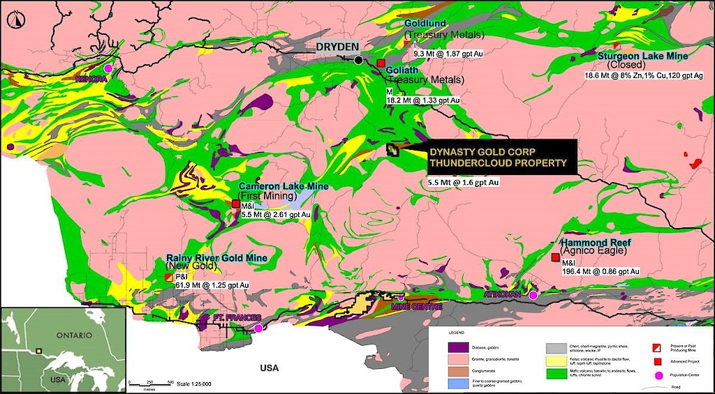
The Thundercloud Property is located in the central Wabigoon greenstone belt in Western Ontario. The geological setting is analogous to the Abitibi belt in Eastern Ontario but Thundercloud is much less explored. The belt contains numerous gold showings, several deposits and historic past producers including the Big Master Mine (1902-1943) and the Laurentian Mine (1906-1909). Results to date indicate excellent potential to define bulk-tonnage orogenic gold mineralization with potential for high grade mineralization. Close to 30 M oz of gold has been discovered in the area in recent years.
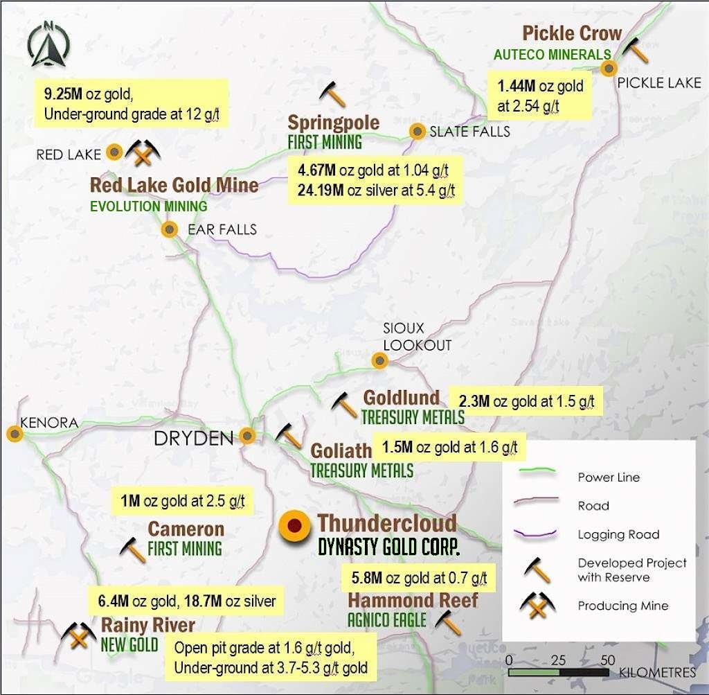
The Property consists of 2,250 hectares, located 47 kilometres southeast of Dryden, northern Ontario. It is readily accessible from the Trans-Canada Highway (Hwy 17). Dryden is a resource-based town with excellent infrastructure necessary for mining operations. Several large scale mining operations in the area include New Gold's Rainy River Mine (6.4 million oz gold and 18.7 million oz silver), and Evolution Mining's Red Lake Gold Mine (9.25 million oz gold) as well as several multi-million ounce gold reserves, defined at the Canadian Malartic Hammond Reef deposit (5.8 million oz gold) by Agnico Eagle, and First Mining Gold's Springpole deposit (4.9 million oz gold).
(Click on map to view)
Regional Geology
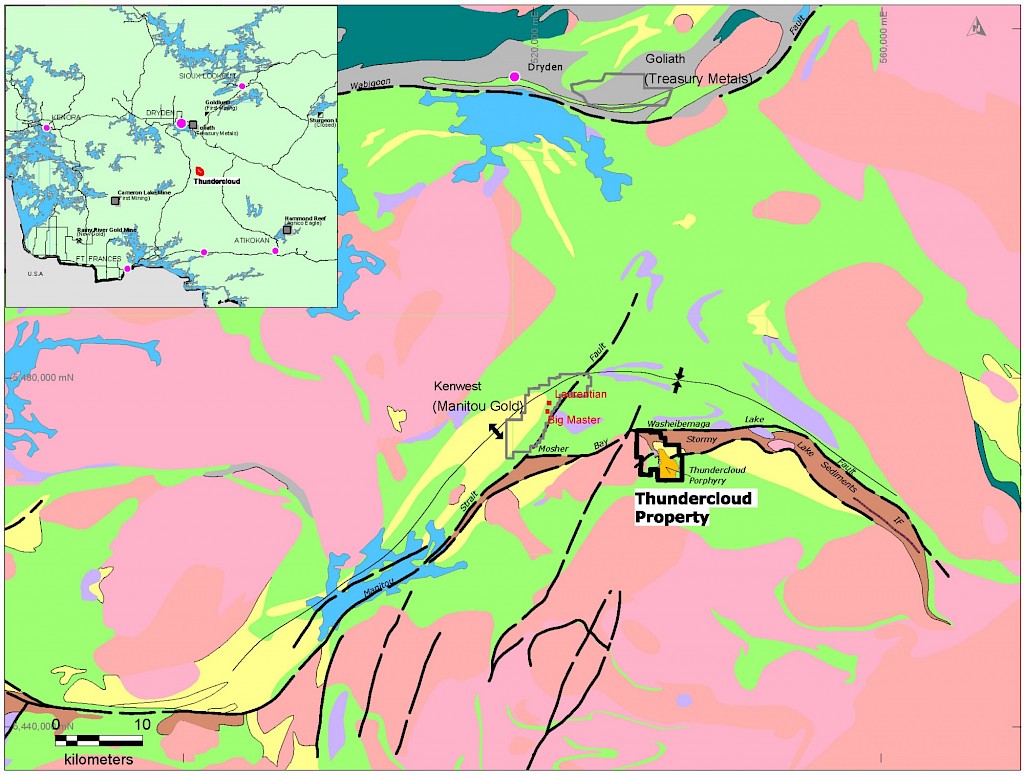
The Manitou-Stormy Lakes Greenstone belt lies within the western Wabigoon Subprovince, a granite-greenstone terrane of the Superior Province. A number of thick volcano-sedimentary sequences consisting of mafic to felsic lavas and associated intrusions and pyroclastic rocks, all of which are generally overlain by sedimentary sequences, characterize the belt. Gold-bearing mineralized zones are focused in a north-south corridor within the central portion of the property. Host rocks comprise tholeiitic basalts overlain by a suite of clastic rocks of the Stormy Lake Group, including conglomerates, breccias and sandstones with a wide range in matrix and clast compositions. These rocks form a structurally complex central corridor between the intermediate composition Taylor Lake stock (2695±4 Ma: Davis et al. 1982) to the west and the felsic Thundercloud quartz-feldspar porphyry ("QFP") to the east.
(Click on map to view)
Property Geology and Mineralization
Gold is associated with hydrothermal alteration domains characterized by biotite-magnetite alteration with minor quartz veins and pyrrhotite. Biotite-magnetite alteration is in turn cut by chlorite-carbonate and pyrite. Both pyrrhotite and pyrite occur as disseminations, clots and veins, and are variably strained. In general, there is a correlation between sulphide concentration and gold grade, though a high ratio of pyrrhotite relative to pyrite appears to be the key for gold enrichment.
Given the importance of magnetite and pyrrhotite in the hydrothermal assemblage, several untested ground magnetic targets warrant trenching and/or drill testing. The presence of sulphides in association with gold suggests that chargeability is a key targeting tool, and this is confirmed by an excellent association of gold with a strong chargeability anomaly in the Pelham area. Additional modelled chargeability anomalies remain untested.
Past Exploration Work
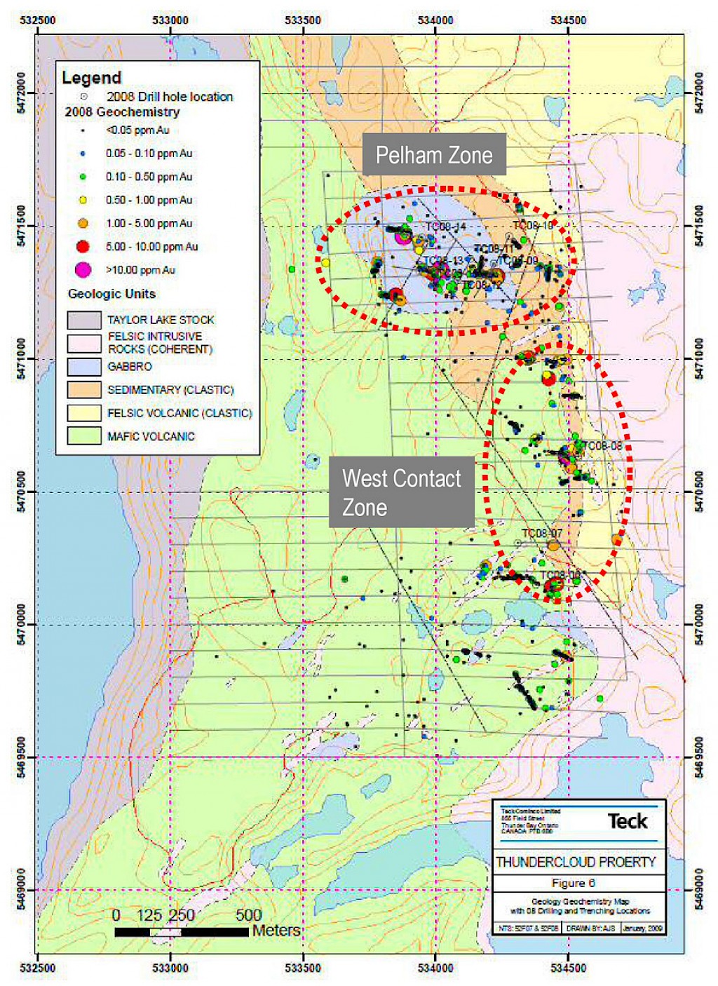
Pelham Zone
Most of the drilling was done in a small part of the Pelham Zone. The NI 43-101 report prepared by Fladgate Exploration Consulting Corporation ("Fladgate") for Dynasty based on 66 core holes totaling 12,093 meters of historic drilling estimates an Inferred Resource of 182,000 ounces gold at 1.37 g/t for Pelham Zone.
The Pelham Resource of gold mineralization as presented by Fladgate is a gold vein deposit in a fractionated gabbro. Exploration in the Pelham Zone has been completed to a relatively advanced stage. The gold mineralization in the Pelham area displays relatively good continuity, allowing an estimate of the mineral resource. The gold mineralization exhibits a very strong lithologic (gabbro-sediment contact) and structural controls. Gold is present in a variety of styles including: veinlets, clots, and disseminated sulphides.
Most of the drill data used to support mineral resource calculation in the Pelham Resource was from drilling carried out by Teck Resources Limited ("Teck") and Laurentian Goldfields in 2007 to 2011. Their drill holes intercepted mineralization at depths of up to 350 m below surface. Gold mineralization has been defined along a strike length of 430 m and 150 m down-dip.
Highlights of drill results from historic work and the recent drilling by Teck (2007 and 2008) and Laurentian Goldfields (2011) include:
- 113.0 m @ 1.72 g/t Au (88-10)
- 60.30 m @ 1.46 g/t Au (88-05)
- 55.25 m @ 2.19 g/t Au (TC08-11), including 1 m @ 37.5 g/t Au, 9.34 m @ 7.91 g/t Au and 21.73 m @ 4.63 g/t Au
- 29.66 m @ 0.77 g/t Au including 9.04 m @ 2.20 g/t Au (TC08-09)
- 68.8 m @ 1.55 g/t Au (TC11-001)
- 81.0 m @ 1.31 g/t Au (TC11-006)
The highest grade from historical drilling returned up to 192.7 g/t gold over 0.55 meters.
(Click on image to view)

West Contact Zone
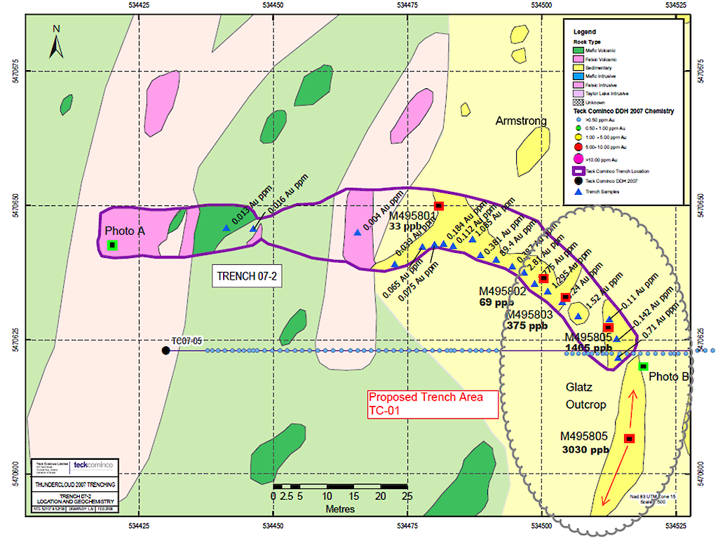
Trench samples collected from the West Contact Zone during the 2006/2007 exploration campaign returned between 1.0-9.8 g/t gold, including 8.02 g/t gold over 39.0 m and 89.4 g/t gold over 3.0 m. Little follow up work was done in this area which will be one of the main focuses of the Company's 2021 exploration program.
(Click on image to view)

Work in progress
The Company has received a drill permit in early spring of 2021. Preparation for its maiden drill program is underway. Drill targets will focus on testing the projected north-east plunge mineralization in the Pelham Zone for resource expansion. In the West Contact Zone, additional trenching of known mineralization will centre at Glatz Outcrop to better define structural control and confirmation drilling will follow. A detailed exploration program was announced in early summer (refer to press release on July 5, 2021).
Please refer to press releases on July 12, 2021, August 5, 2021, September 13, 2021 and December 13, 2021 for exploration updates of the 2021 work programs.
Please refer to the press release on July 28, 2022 for high resolution airborne magnetic survey update on the Thundercloud property.
For 2022 phase 1 drill program assay results, refer to press releases on January 10 and 16, 2023, and February 13, 2023 for updates.